Cities provide spatial contexts for populations and economic activities. Determining the spatial-temporal patterns of urban expansion is of particular significance for regional sustainable development. To achieve a better understanding of the spatial-temporal patterns of urban expansion of Korla City, we explore the urban expansion characteristics of Korla City over the period 1995-2015 by employing Landsat TM/ETM+ images of 1995, 2000, 2005, 2010, and 2015. Urban land use types were classified using the supervised classification method in ENVI 4.5. Urban expansion indices, such as expansion area, expansion proportion, expansion speed, expansion intensity, compactness, and fractal dimension, were calculated. The spatial-temporal patterns and evolution process of the urban expansion (e.g., urban gravity center and its direction of movement) were then quantitatively analyzed. The results indicated that, over the past 25 years, the area and proportion of urban land increased substantially with an average annual growth rate of 15.18%. Farmland and unused land were lost greatly due to the urban expansion. This result might be attributable to the rapid population growth and the dramatic economic development in this area. The city extended to the southeast, and the urban gravity center shifted to the southeast as well by about 2118 m. The degree of urban compactness tended to decrease and the fractal dimension index tended to increase, indicating that the spatial pattern of Korla City was becoming loose, complex, and unstable. This study could provide a scientific reference for the studies on urban expansion of oasis cities in arid land.
Urban expansion is a phenomenon reflecting the demand for land caused by industrial growth and population increase (Mohurd, 1999; Qiao et al., 2016; Aimaiti et al., 2016). It is a result of urbanization, the process of people migrating from rural to urban areas (Liu et al., 2012; Sun et al., 2013; Liu et al., 2016). However, unplanned and poorly-planned urban expansion usually leads to inefficient use of land, loss of farmland, environmental pollution, and ecological degradation (Tan et al., 2005). China has experienced rapid urbanization since 1978, and the urbanization rate reached 56.10% in 2015 (NBSC, 2016). The rapid urban expansion caused dramatic changes in the landscapes and had substantial impacts on social, economic, and natural environment (Chen et al., 2009; Zhang et al., 2012; Wang et al., 2013; Nian et al., 2014; Yang et al., 2015).
Studies of urban expansion mainly focused on two aspects, the qualitative and quantitative measurement of urban spatial patterns, and the demarcation of urban spatial expansion. Frankhauser (1990) provided a series of analysis results and calculation methods based on the fractal dimension. Batty (1994) analyzed the spatial expansion pattern of urban areas and the structure of urban land use by employing fractal theory. Gradient analysis and landscape metrics were often adopted to quantify land spatial patterns (Collins and Woodcoch, 1996; Luck and Wu, 2002). Long et al. (2009) determined the urban growth boundary based on binding cellular automata, whereas Yang et al. (2010) noted a distinction between rigid and elastic growth boundaries. Numerous studies were performed in many large cities of China (Liu et al., 2002; Shi et al., 2009; Xiao and Tian, 2014; Zhao et al., 2015), including characterizing the spatial-temporal patterns, detecting the dynamics, and modeling urban land uses. A few studies also examined the urban expansion in the arid and semi-arid areas of northwestern China. For example, Kasimu et al. (2013) extracted the spatial-temporal characteristics of urban expansion of 16 oasis cities in Xinjiang using remote sensing (RS) and geographic information system (GIS) techniques. However, there is a lack of systematic, comprehensive, long term studies that examine the urban expansion of typical individual cities, particularly the oasis cities of southern Xinjiang.
Urban expansion studies often use methods and indices to analyze the intensity, speed, anisotropy, and spatial heterogeneity of expansion. These methods and indices include average patch area (Yu and Ng, 2007), compactness index (Hagen-Zanker and Timmermans, 2008; Shi et al., 2015), gradient analysis (Vizzari, 2011), shape index (Kasimu and Aimaiti, 2012), fractal dimension (Nie et al., 2015), sprawl intensity (Boori et al., 2015; Mohammady and Delavar, 2016), spatial metrics (Aithal and Ramachandra, 2016; Debbage et al., 2016), and percentage of built-up area (Liu et al., 2017). However, these methods and indices are often difficult to apply to the oasis cities in the arid and semi-arid areas that are scattered in distribution and irregular in shapes. In that regard, RS images and GIS techniques can provide frequent and accurate land observation data to detect spatial changes and to assess urban expansion trends (Yeh and Li, 1999; Weng, 2001). In contrast to traditional statistical data, RS technology is objective and can offer real-time coverage at a lower cost for quantitatively analyzing the spatial-temporal patterns of urban expansion (Kasimu and Maimaitiming, 2012; Boori et al., 2015).
It is commonly known that economic development and urban expansion are mutually influenced and restricted. The year of 1990 was a historical turning point for the economic development of Korla City due to the Natural Gas Transmission Project from West to East originated here and the establishment of the Tarim Oilfield Company. This study aimed to reveal the spatial-temporal patterns of urban expansion in Korla City over the period 1990-2015 and to explore the driving forces of the urban expansion. The results can provide scientific supports for economic development and land use management for Korla City.
Korla City, the capital city of the Bayingolin Mongolian Autonomous Prefecture, Xinjiang Uygur Autonomous Region, China, is located in the hinterland of Euro-Asia continent (41° 10′ 48′ ′ -42° 21′ 36′ ′ N, 85° 14′ 10″-86° 34′ 21″E; 950 m a.s.l.; Fig. 1) and situated at the northeastern edge of the Tarim Basin. It is the largest city in southern Xinjiang and the second largest city in Xinjiang. It covers an area of 7.268× 10³ km² and is an important political, economic, and cultural center. At the end of 2015, the non-agricultural population (0.36× 10⁶) accounted for 65.06% of the total population (0.56× 10⁶); the GDP was 66.40× 10⁹ yuan, and the GDP per capita was 112× 103 yuan; the secondary and tertiary industry outputs were 49.40× 10⁹ yuan and 13.00× 10⁹ yuan, accounting for 74.42% and 19.54% of total GDP, respectively.
In this study, we focused on the core urban built-up areas, where the public facilities and municipal utilities are available and convenient, and the buildings are relatively contiguous. The core urban built-up areas include all artificially constructed elements such as roads, factories, residential areas, and parks with water and vegetation. According to this concept, we extracted the main functional area rather than the administrative area from the RS images (Fig. 1).
Landsat TM/ETM+ images of 1990, 1995, 2000, 2005, 2010 and 2015 were obtained from the official website of the United States Geological Survey (https://www.usgs.gov) and the Geo-spatial Data Cloud of China (http://www.gscloud.cn). To ensure the clarity, we selected the images with cloud coverage percentage less than 10% (Table 1). The socioeconomic data were obtained from the Xinjiang Statistical Yearbook (Statistics Bureau of Xinjiang Uygur Autonomous Region, 1991-2016) and from the Korla City government website (http://www.xjkel.gov.cn). Land use maps were provided by the Korla Land and Resource Bureau. We also performed two field surveys in 2010 and 2015, respectively.
The ENVI 4.5 was used for image processing and the ArcGIS 10.1 was used for mapping and spatial analysis. SPSS 19.0 and Microsoft Excel were used for statistical analysis.
| Table 1 Remoting sensing (RS) data |
ENVI 4.5 was used to implement geometric corrections and atmospheric corrections to improve the accuracy of the original image data. Since the images of 2005 and 2010 included image strips, the gap fill method was applied to remove the “ noise” information from the images.
According to the urban land resource classification system, which is promoted by the “ National Resources & Environment Survey and Dynamic Monitoring Using Remote Sensing” of Chinese Academy of Sciences, we classified the land use types in the urban built-up-area into 6 categories: urban land, farmland, woodland, water body, grassland, and unused land (Liu, 1997). During the in situ investigation, we found there was no obvious grassland within the built-up areas over the 25-year study period. Thus, the category of grassland was ignored.
The maximum likelihood algorithm was applied to perform supervised classification. In the interpretation, the band composite used for visualization for 2015 images was band 4, 5 and 6 (shown in blue, green and red, respectively), whereas the composite of band 3, 4 and 7 (shown in blue, green and red, respectively) were used for the other years. The spectral differences among the different land use types were significant, and the land use types could be easily identified using these bands (Chen et al., 2009). To improve the accuracy, we selected at least 100 ground-truth pixels from each land use type, which were extracted based on field investigations of 2010 and 2015 and also on land use maps for the other periods. The classification results were compared against the high spatial resolution data (higher than 2.5 m) in Google Earth and also with the land use maps from the other sources. Post classification method was applied to eliminate the influence of such problems as spectral dissimilarity of same land use classes and the spectral similarity of different land use classes. The classification accuracy was tested by human-computer interaction and was checked using the reference data collected from field investigations and land use maps. As can be seen from Table 2, both the overall accuracy and the Kappa coefficient values were high enough for the study period, indicating that the classification results were acceptable and ready for further analysis.
| Table 2 Accuracy assessment of classification |
We evaluated the urban spatial and temporal patterns using land use transfer matrix, urban gravity center, urban expansion indices, and urban spatial pattern indices. Land use transfer matrix can indicate the source of expanded urban land and the degree of contribution from different land use types to the expansion. The urban gravity center indicates the urban movement direction and can help to determine the expansion mode of the urban land to some extent. Urban expansion indices can quantitatively describe the urban expansion features. Urban spatial pattern indices can provide a system-level analysis to describe the forms and the process of urban expansion.
3.3.1 Land use transfer matrix
We used the land use transfer indices (Eq. 1) to evaluate the specific contribution of each land use type to urban land use. The matrix can quantitatively disclose the mutual conversion relationships among different land use types and can specifically and comprehensively describe the areas, structural characteristics and change trends for each land use type.
LCC=Cn× 10+Cn+1. (1)
Where, LCC is the land cover change; Cn and Cn+1 are the land use types before and after a set of changes, respectively; and n is the study year (Li et al., 2009).
3.3.2 Urban gravity center
The urban gravity center can describe the changes in the urban land spatial distribution through following the moving distance and direction of the center. The regional center of gravity model is derived using concepts from mechanics to express the coordinates (Xt, Yt) of the regional gravity center (Eq. 2; Wang et al., 2013).

Where, Xt and Yt indicate the longitude and latitude of the gravity center in the study year t, respectively; Xi and Yi indicate the geometric centers of land use type i, respectively; and Cti represents the area of land use type i in the year t.
Gravity center movements include two aspects of distance and direction. The moving distance described how far the gravity center moved over a certain period while the moving direction indicates to which direction the urban expanded. The corresponding formula is as Equation 3.

Where, D is the distance moved; X1and Y1are the initial coordinates; and X2 and Y2 are the final coordinates of the urban gravity center.
3.3.3 Urban expansion indices
Urban expansion process can be quantitatively analyzed by the expansion speed and expansion intensity (Aimaiti et al., 2016). The expansion speed is the degree of expansion relative to the total urban land in preceding year (i.e., the year before the studied year), whereas the expansion intensity is the average annual growth rate of urban expansion during a particular study period. They can provide comprehensive assessments on the degree of urban expansion in terms of speed, area, ratio, and intensity.
Expansion speed (ES; Eq. 4; Kasimu et al., 2013) represents the degree of urban expansion of one specific study year in comparison with the degree of the preceding year. It was used to describe the overall changes in size and trends of the urban expansion.

Where, Ln and Ln+i are urban areas in the years n and n+i, respectively; and n represents the length of the study period (Kasimu et al., 2013).
Expansion intensity (EI; Eq. 5) is the average annual growth rate of urban expansion over a period. It represents the annual average ratio of the increase in urban area to the initial total urban area.

Where, UAn+i and UAi indicate the urban area in the yearsn+i and i, respectively; n is the length of the study period (Zhao and Hu, 2006).
For Equations 2 and 3, the length of the study period n was equal to 5 years for each of the five study periods (1990-1995, 1995-2000, 2000-2005, 2005-2010, and 2010-2015), and was equal to 25 years for the total study period 1990-2015.
3.3.4 Urban spatial pattern indices
The compactness and fractal dimensions are widely used to quantitatively evaluate the urban spatial patterns (Nie et al., 2015) and these indices can reveal the spatial shape, stability, and complexity of city boundaries. Compactness (Eq. 6) is an indicator reflecting the shape of a city. It provides a characterization of the basic features of an urban space and land use efficiency. Its value falls in the range of 0-1 and the higher the value is, the higher the compactness of an urban will be. Low values indicate loose urban patterns. A circle is the most compact graphical form and the compactness of a circle is equal to 1.

Where, C is the compactness; A is the area (m² ); and P is the perimeter (m) of the urban land (Kasimu et al., 2013).
Fractal dimension value (Eq. 7) is often used to indicate the degree of complexity and stability of city boundaries. Based on calculated values of the fractal dimension, the morphological characteristics of a city’ s spatial expansion during different periods can be inferred.

Where, D is the fractal dimension; A is the area (m² ); and P is the perimeter (m) of the urban land (Kasimu et al., 2013). In general, the value of the fractal dimension is in the range of 1-2. The larger the value is, the more complex the city boundary is. If the value is less than 1.5, the shape of the city tends to be simple. If the value is more than 1.5, the city is in a state corresponding to Brownian random motion, and the shape of the city tends to be complex (Tu et al., 2013).
Based on the land use classification results, we produced land use classification maps for 6 different years (Figs. 2 and 3) using the ArcGIS 10.1 and calculated the relevant parameters. The areas occupied by urban land, farmland and unused land changed significantly over the whole study period. In particular, the urban land increased dramatically and mostly expanded to the southeastern direction. The unused land in the northern and southern parts of the city was fully utilized. The rapid increase in urban land well reflects the urban expansion trend.
 | Fig. 3 Spatial distribution of different land use types of Korla City in 1990 (a), 1995 (b), 2000 (c), 2005 (d), 2010 (e), and 2015 (f) |
The urban area displayed a linear upward trend over the study period. It increased by 63.65 km² from 16.77 km² in 1990 to 80.42 km² in 2015 with an annual expansion rate of about 15.18%. The farmland area was 37.05 and 34.37 km² in 1990 and 2015, respectively. From 2005 onward, the farmland area increased gradually and mainly concentrated in the northwestern city, and reached the peak in 2010 and then dropped. The woodland area presented a stable increasing trend since 2000 and reached 38.56 km² in 2015. The additional woodland was mainly concentrated in the central and southeastern city where the considerable urban expansion occurred. The water body areas include the Konqi River, Tarim River, and reservoirs in the southern city, which were relatively stable over the study period. The reduction in unused land was sharp and significant. During the early part of the study period, the unused land was mainly distributed in the northeastern, eastern, and southeastern city with an area of 155.69 km² in 1990. The unused land area was dropped to 72.01 km² in 2015 and the annual decreasing rate was about 4.65%.
4.2.1 Urban area expansion
The urban area expanded significantly over the 25-year study period (Fig. 4). Using the urban land layer, the urban expansion maps were extracted by overlay analysis in ArcGIS 10.1 for the 6 periods (Fig. 5). The proportion of urban land expansion increased from 7.34% to 35.24%. The urban land expansion presented an accelerated trend over the entire study period.
4.2.2 Urban land transfer matrix
Figure 6 is the urban land transfer matrix maps for the 6 study periods and reflects the different land use types that were transferred to urban land type in each study periods. The total area for the entire period was not equal to the sum of the areas of the five sub-periods because the urban land was sometimes transferred back to the non-urban lands (Table 3).
Overall, the largest contributor to the urban expansion was the unused land and the second largest contributor was the farmland. In 1990, the area of unused land was about 155.69 km² , accounting for 27.82% of the total urban area of 2015. During the period 2010-2015, 20.90 km² of unused land were taken by the urban land, accounting for the largest increase among all of the study periods. In 1990, most of the central part of the city was farmland with an area of about 37.05 km² , in which about 18.62 km² was transferred into urban land by 2015.
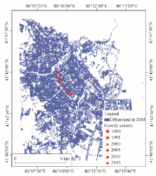
We calculated the coordinates and movements of the urban gravity centers for the study periods (Table 4). The movements of the center were presented in Figure 7. The urban gravity center moved towards northwest in 1990-1995 and moved towards the southeast continuously from 1995 to 2015. A small amount of unused land in the northeastern city was occupied by urban land. Since 1995, a large amount of unused land in the southern city was gradually taken by the urban land and the gravity center shifted towards the southeast accordingly. The gravity center moved 2118.46 m over the period 1990-2015.
4.4.1 Expansion speed and intensity
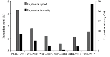
According to the data extracted from ArcGIS 10.1, the expansion speed and the expansion intensity were calculated by Equations 4 and 5 using SPSS. The results were presented in Figure 8. Within each of the study periods, the expansion speed and expansion intensity were stable and the differences were not large; the values varied in the range of 6%-9%. The maximum values of both the speed (8.27%) and the intensity (9.35%) appeared in 1990-1995.
4.4.2 Urban spatial pattern changes
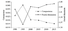
The compactness and the fractal dimensions can be used to describe the urban spatial patterns. The maximum compactness value of 1.3625 and the minimum fractal dimension value of 0.040 occurred in 1995 and the city was relatively compact and stable with a simple shape. Both the compactness and the fractal dimensions presented obvious turning points in 1995 (Fig. 9). In 1990-1995, the newly added urban land converted from the unused land was mainly located in the northern city and on both sides of the Konqi River; the plots of unused land in the central city taken by the urban land were small in size and large in numbers. Therefore, the compactness and the fractal dimension of the city had no significant change although the urban land increased significantly. Since 1995, the land plots converted to urban land were disperse, the compactness dropped down to 0.0209 and the fractal dimension jumped up to 1.4321 in 2000. Since then the compactness gradually decreased to 0.0156 and the fractal dimension gradually increased to 1.4432 in 2015. The urban spatial pattern reached the most complex, unstable and loose stage over the entire study period.
4.5.1 Geographical features
Korla City is a typical oasis city in southern Xinjiang with dry climate and scarce water resources. The urbanization was restricted by both the topographic and climatic conditions. The city is bordered by the Horo Mountains to the north and by the Kuruktag Mountains to the east. The city is surrounded by salinized and desertified lands.
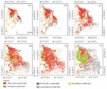 | Fig. 6 Urban land transfer matrix of Korla City in different periods. (a), 1990-1995; (b), 1995-2000; (c), 2000-2005; (d), 2005-2010; (e), 2010-2015; (f), 1990-2015. |
| Table 3 Land use types taken by urban land of Korla City during the period 1990-2015 |
| Table 4 Movement of urban gravity center of Korla City |
4.5.2 Population
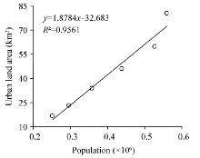
The rapid increased urban population was the most important factor driving the urban expansion. Over the 25-year study period, the population of the Korla City increased from 0.251× 10⁶ in 1990 to 0.559× 10⁶ in 2015 with an average annual growth rate of about 4.91%. Dramatic population growth triggered high demands for residential, commercial and infrastructure (hospitals, sewage treatment plants and schools) lands. The correlation coefficient (R2) between the population and the urban land area was 0.9561 (Fig. 10), lending a strong support to our proposition that increased urban population was the most important factor driving the urban expansion.
4.5.3 Rapid economic development
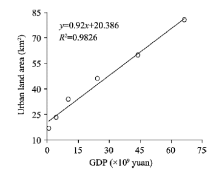
The essence of urban expansion is a comprehensive process of economic development. With the exploration of the Tarim Oilfield in 1989 and the completion of the Natural Gas Transmission Project from West to East in 2007, the per capita GDP of Korla City increased substantially from 2.76× 10³ yuan in 1990 to 112× 103 yuan in 2015 and the total GDP increased from 0.71× 10⁹ to 66.37× 10⁹ yuan (Fig. 11). At the same time, the output from tertiary industry was 0.24× 10⁹ yuan in 1995 and 12.97× 10⁹ yuan in 2015. The correlation coefficient between the GDP and the urban land area was 0.9826 (Fig. 11), indicating that the economic expansion is another important factor driving the urban expansion.
4.5.4 Government policies
Administrative regulations play an important role in guiding the development of the city and also in restricting undesired urban expansion. Several significant events and strategies have promoted the development of Korla City and the corresponding urban expansion. These events and strategies include the Korla-Lopnur Integration Policy that started its enforcing stage in 2005, and the first and second Xinjiang Work Forums that took place in 2010 and 2014. The implementation of these policies, on one hand, accelerated Korla’ s economic development considerably. Specifically, from 1990 to 2015, the average annual growth rates of the regional GDP and the per capita GDP were 277.6% and 178.6%, respectively. On the other hand, these factors triggered Korla City to expand at the cost of other land types, including farmland, woodland, water body, and unused land.
4.5.5 Well-linked traffic lines
Korla City is the most important transportation hub in southern Xinjiang. It links southern Xinjiang with northern and eastern Xinjiang. It is also well linked with many prefectures and cities in southern Xinjiang. Roads passing through Korla City include the Desert Highway to Hotan Prefecture, the National Highway 315 to Aksu Prefecture and Kashgar Prefecture, etc. Aviation is also highly developed here and the Korla Airport is the second-largest airport in Xinjiang. In particular, the operation of the Southern Xinjiang Railway Line in 1999 brought unprecedented development opportunities to Korla City. The well-linked traffic lines provided the necessary conditions for urban expansion.
This study quantitatively analyzed the urban development process of Korla City using the widely-used indices to describe the spatial and temporal patterns of the urban expansion. Over the study period from 1990 to 2015, due to the rapid development of the economy and the speedy growth of the population, the urban land increased greatly at the expenses of unused land and also other non-urban lands. The urban pattern was getting complex and unstable with the city compactness dropped and the fractal dimension increased. However, the rapid urbanization is often accompanied with social and environmental problems. With the rapid development of the core urban built-up area, the natural environment along the Konqi River was deteriorated. In addition, the newly expanded area in the southern city is very far from the city center, and the farther distances also created problems for city management. This study is a preliminary investigation of the expansion for a typical oasis city in the arid and semi-arid lands. Future research should employ images with higher spatial resolution than those of Landsat TM/ETM+ to elevate our understanding of the oasis city dynamics.
This study was funded by the National Natural Science Foundation of China (41161063, 41261090, 41361043, 41661036), the National Natural Science Foundation of China-Xinjiang Mutual Funds (U1603241), the Xinjiang Uygur Autonomous Region Science and Technology Support Project (201591101), the special fund of the Xinjiang Uygur Autonomous Region Key Laboratory (2014KL005, 2016D03001), and the Open Project Fund of the Key Laboratory of Oasis Ecology of the Education Ministry, Xinjiang University (040079).
The authors have declared that no competing interests exist.
| [1] |
|
| [2] |
|
| [3] |
|
| [4] |
|
| [5] |
|
| [6] |
|
| [7] |
|
| [8] |
|
| [9] |
|
| [10] |
|
| [11] |
|
| [12] |
|
| [13] |
|
| [14] |
|
| [15] |
|
| [16] |
|
| [17] |
|
| [18] |
|
| [19] |
|
| [20] |
|
| [21] |
|
| [22] |
|
| [23] |
|
| [24] |
|
| [25] |
|
| [26] |
|
| [27] |
|
| [28] |
|
| [29] |
|
| [30] |
|
| [31] |
|
| [32] |
|
| [33] |
|
| [34] |
|
| [35] |
|
| [36] |
|
| [37] |
|
| [38] |
|
| [39] |
|
| [40] |
|
| [41] |
|
| [42] |
|
| [43] |
|


